


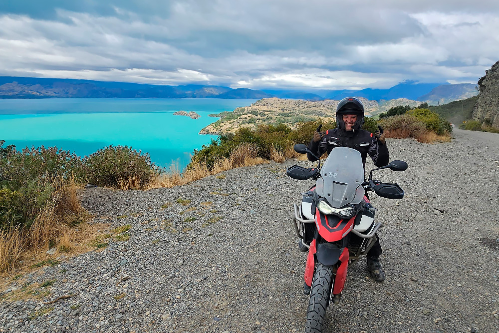
There is a difference between a beautiful road and a road that resets your sense of scale. The Carretera Austral is the second kind. It runs about 1,240 km as Chile’s Ruta 7, from Puerto Montt to Villa O’Higgins, through cold rainforest, fjords, hanging glaciers and lakes of an improbable blue. It is not the hardest road in South America, but it is one of the most remote — and riders who arrive without planning the ferries, the fuel and the gravel find that out the hard way.
This guide runs the Carretera north to south with what matters on a motorcycle: where it is paved and where it is gravel, where to refuel, which ferries need booking, and why the far south is a dead end.
What the Carretera Austral is
Ruta 7 was pushed through from the 1970s onwards to connect Chilean Patagonia to the rest of the country — a region that until then communicated by sea. The result is a road that exists more through political will and engineering than through geography: it threads between mountain and fjord, and at four points it simply gives up and becomes a ferry.
Paving advances every season. Much of the northern section and the area around Coyhaique is now sealed, and the gravel is concentrated in the south, particularly beyond Cerro Castillo and south of Cochrane. Riders who want the Carretera in its rawest state are working against a closing window.
North to south, section by section
Puerto Montt to Hornopirén: a road that starts at sea
The first day teaches you the logic of the Carretera. Puerto Montt to Hornopirén is roughly 110 km of tarmac with one short ferry in the middle (Caleta La Arena to Caleta Puelche). Bays, salmon farms and volcanoes on the horizon. Technically the easiest stretch of the whole route.
The double ferry at Hornopirén and Pumalín Park
Between Hornopirén and Caleta Gonzalo there is no road: two ferry crossings in the same day, with a dirt section between them. This is the crossing that must be booked in advance — vehicle slots sell out in high season, and missing it costs a full day. On the far side, Pumalín Park brings the densest, wettest forest on the route.
Chaitén to Coyhaique: a hanging glacier and worthwhile detours
Chaitén is the first serious refuelling point after Hornopirén. From here to Coyhaique is roughly 420 km and the most varied part of the Carretera: Queulat National Park with its hanging glacier, La Junta, Puyuhuapi. The detour to Futaleufú is worth a spare day. Tarmac and gravel alternate.
Coyhaique to Puerto Río Tranquilo: the scenic core
Coyhaique is the largest town in the region and the best place to sort tyres, oil, cash and repairs. Leaving it, the road passes Cerro Castillo — one of the most photographed stretches of the route — then follows Lago General Carrera, the second-largest lake in South America. Boats leave Puerto Río Tranquilo for the Marble Caves, worth half a morning.
Río Tranquilo to Cochrane and the Caleta Tortel detour
Here tarmac thins out and gravel takes over. This is also where you find the stretch Chilean riders nicknamed “los 73 malditos” — 73 km of gravel that works as an entrance exam for the rest of the south. Cochrane is the last reliable fuel before the road ends. With time to spare, detour to Caleta Tortel, a village built on wooden walkways over the fjord.
Puerto Yungay to Villa O’Higgins: where the road ends
The final ferry (Puerto Yungay to Río Bravo) is short and free, but it runs to a fixed timetable with few daily departures — arriving late costs a night. Beyond it, around 100 km of isolated gravel to Villa O’Higgins, the end of Ruta 7 and one of the most remote places you can reach by motorcycle in South America.
The Villa O’Higgins dead end
There is no motorcycle crossing between Villa O’Higgins and El Chaltén. The connection is a boat across Lago O’Higgins plus a hiking and cycling trail — bikes do not pass. Riding down to Villa O’Higgins means riding the same 200 km back up to Cochrane.
That is not a reason to skip it; it is a reason to plan. Reaching the end of the road and returning costs two days. If your goal is to combine the Carretera with El Chaltén and El Calafate, cross the border further north — at Chile Chico on Lago General Carrera, or at Paso Roballos — and continue on Argentina’s Ruta 40. That is exactly how the ROXMOTORS Patagonia and Carretera Austral expedition solve the routing: a linear crossing with no repeated road.
Ferries: the bookings that shape your route
Four points on the Carretera turn from road into water. Two deserve particular attention:
- Hornopirén–Leptepu / Fiordo Largo–Caleta Gonzalo — the critical one. Advance booking essential in season, few departures per day.
- Puerto Yungay–Río Bravo — short, free, no booking, but a rigid timetable.
- Caleta La Arena–Caleta Puelche — frequent, no booking needed.
- Chile Chico–Puerto Ibáñez — crosses Lago General Carrera and shortens the run to the Argentine border considerably.
Confirm the current season’s timetables before locking your itinerary: schedules change year to year, and one missed ferry rearranges the entire trip.
Fuel: where to fill up
The rule on the Carretera is simple: fill up whenever you can, not whenever you need to. Reliable points from north to south are Puerto Montt, Hornopirén, Chaitén, La Junta, Coyhaique, Puerto Río Tranquilo and Cochrane. South of Cochrane supply is sparse and uncertain — carry a reserve if your bike cannot comfortably cover 300 km.
Gravel: what to expect and how to ride it
Carretera gravel is loose, with large stones in places and fine sand in others. The technique is the same as any dirt road: steady speed, steady throttle, weight on the pegs, eyes far ahead and light hands. The classic mistake is grabbing the brakes when startled — that locks the front wheel and puts you down.
- A 50/50 tyre is the minimum for the southern section.
- Measured rear brake; front brake very sparingly.
- Watch the ridge of soft gravel that builds up in the centre of the road and along the edges.
- Stones thrown by trucks are the most common cause of broken headlights and screens: keep your distance.
If you have never ridden long gravel sections on a loaded adventure bike, a weekend of training beforehand is the difference between enjoying it and enduring it — that is what the Off-Road Bigtrail modules are for.
Weather and best season
The Carretera is the wettest part of Patagonia: the northern half sees rain in any month of the year. The riding season runs November to March, with December to February offering long days and the most stable weather the region can manage. March brings autumn colour and fewer people, with less predictable conditions.
Whatever the month: count on rain. Genuinely waterproof kit and dry bags are not luxuries here.
North to south, or south to north?
Most riders head south from Puerto Montt, because the landscape escalates in that direction and rental logistics are simpler. The case for the reverse is wind: riding north it tends to push rather than brake, and the afternoon sun sits behind you for photographs. Neither choice is wrong — decide by your arrival and departure logistics, not by the wind.
How many days to allow
- 7 days — Puerto Montt to Coyhaique at a civilised pace, or Coyhaique to Villa O’Higgins and back.
- 10 days — the full Carretera end to end, including the run down to Villa O’Higgins and back to Cochrane.
- 14 days — the Carretera plus the Argentine icons (El Chaltén, El Calafate, Torres del Paine), crossing the border to the north.
And the rule that applies to all of Patagonia: one spare day per week, held back for the weather, the ferry, and the day the landscape simply asks you to stop.
Frequently asked questions
Is the Carretera Austral all gravel?
No. Much of the northern section and the Coyhaique area is paved, and paving advances every year. Gravel is concentrated in the south — beyond Cerro Castillo and especially south of Cochrane.
Can I ride the Carretera Austral on a road bike?
As far as Coyhaique, carefully, yes. From south of Cerro Castillo onwards, a road bike on road tyres turns the trip into work. An adventure bike on dual-sport tyres is the sensible choice.
Do I need to book the ferries in advance?
The Hornopirén crossing, yes, and well in advance in high season. The others run more frequently or need no booking, but all have fixed timetables — check the current season’s schedule.
Can I ride two-up on the Carretera Austral?
You can, but it is not recommended on the long gravel sections. Extra weight on loose gravel changes how the bike behaves and multiplies rider fatigue.
Before you lock your route
The Carretera Austral works best when you accept that it sets the pace: the ferry, the rain and the gravel do not negotiate. If you would rather ride it with a prepared bike, mechanical support and beds secured in villages where beds are scarce, check the dates on the calendar. For the wider region, our Patagonia motorcycle guide covers the other two axes of the route.